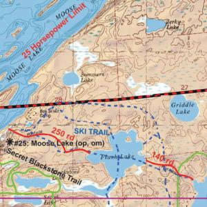
McKenzie Maps - M09 - Moose, Basswood and Snowbank Lakes
All maps are: waterproof, topographic, hillshaded, and feature trails, portages, campsites, and more!
Product Details:
- This map details the eastern end of the Echo Trail.
- BWCA canoe entry points: 25, 27, 28 and 30.
- BWCA motor entry points: F, G and H.
- Kekekabic/Snowbank Trails hiking entry point: 74
- Quetico Park canoe entry point: 62
- Prairie Portage Ranger Station.
- Dimensions: 25" x 30"
- McKenzie Maps use the UTM coordinate system.
Maps are shipped folded in an envelope. Upon request, maps may be shipped in a tube for an additional $5. Submit requests via email or call our catalog at 1-800-223-6565


 Canoe Trips
 Canoe Trips